The Everest of Canals
MSCTY x The Rochdale Canal
‘The Everest of Canals’ – the rise, fall and rise of an overlooked architecture
Creative response by Rebecca Morrill + Guy Tindale
One Saturday evening in 2015, BBC television broadcast a one-off programme that comprised a real-time, unedited, two-hour canal journey. There was no presenter or narration and no soundtrack other than the found sounds of birdsong and the gentle chug of the engine. Half a million people tuned in to watch, some taking to social media to ask if it could be broadcast daily, so relaxing and mesmerising was the experience. The press reviews called it ‘oddly absorbing’ and an ‘unlikely hit’, and the film spawned a number of other canal-related programmes.
Canal travel in 21st-century Britain is now primarily an aspirational pursuit for those in search of a slower pace and a means of reconnecting to sights and sounds of nature. Yet the canals themselves are anything but natural, and have their roots in Britain’s industrial past, radically transforming the landscape and spawning new forms of architecture, above and below ground level. These ambitious constructions have become so integrated into our landscape to be barely noticed today, yet were at the forefront of technology and engineering in their imagining, and were the products of intensive labour in their creation.
For many millennia, most journeys by land were undertaken along simple tracks through fields and woods, on foot or horseback, or leading pack animals. The famously straight Roman roads, some of whose names and routes still exist across Britain, were meant mainly for marching troops, and the technology to build roads for wheeled vehicles became less sophisticated over the centuries following their occupation. Most cargoes travelled by water. Heavy loads could be carried far faster this way, and fragile or valuable items – and passengers – were safer on a raft or coracle on a river than traversing a lonely causeway.
The earliest canals, called ‘navigations’ were created out of existing, natural watercourses. Rivers and streams were tamed, deepened or straightened to establish a channel that would be navigable for boats. The idea of creating an artificial waterway to connect rivers is, however, ancient too, dating back [again] to the Romans. The Foss Dyke [c.AD 120], connects the Trent with the Witham, eleven miles away at the Roman settlement of Lindum Colonia [Lincoln]. This ‘cut’ through the landscape where there had been no water before fell out of use after Roman times, but was then restored in the thirteenth century and has remained in use ever since.
The first ‘cut channel’ to be constructed after the Roman army withdrew was also in low-lying Lincolnshire, some 1,300 years later. The town of Stamford was connected by the River Welland to the sea, around 35 miles away, and in the Middle Ages had grown wealthy manufacturing and exporting cloth and pottery to Europe. By the 16th century however, mills and dams that had sprouted along the river meant that it was no longer passable. A Royal Act [of Elizabeth I] called for an artificial channel to restore the connection, though it was not until a century later in 1670, that the Stamford Canal finally opened after seven years of construction by a small army of local labourers. This trade route remained busy for nearly two centuries, though few traces of it remain now.
In 1699, an Act of Parliament granted extensive powers to acquire land and demolish mills and weirs along the Rivers Aire and Calder in Yorkshire. The banks of the new navigation were lined by towpaths for horses to haul barges. At 14 feet wide, these were far bigger than those used at Stamford, and established the standard ‘broad gauge’ of the later canal network. New functional architecture was developed to enable vessels to ascend. They passed into channels cut parallel to the river and entering sophisticated ‘pound locks’. Lock gates closed at either end of the channel, so the barge could be raised or lowered as sluices were opened by hand, a process that consumed a lot of water.
The Sankey Navigation [c.1755–57] marked another step forward. A trench was cut the entire length of the Sankey Brook, allowing coal to be carried on a circuitous 15-mile route westwards from the Lancashire coalfields to the River Mersey. The next logical step was obvious: to build a canal that would take goods where they needed to go along the most direct route possible, not necessarily following existing rivers at all.
The first ‘pure’ canal took coal from Duke of Bridgewater’s mines in Worsley, Lancashire into Manchester, and later to Runcorn, Cheshire. Building the Bridgewater Canal [1759–61] required the designer, James Brindley, to perform a series of engineering feats, including a ‘staircase’ of ten locks at Runcorn, and the original Barton Aqueduct, ‘one of the Seven Wonders of the Canal Age’, which carried barges high across the River Irwell.
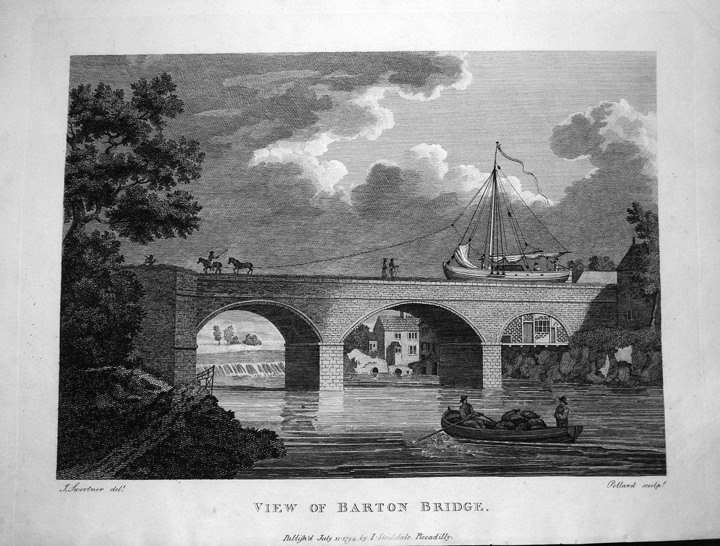
Barton Aquaduct shown in a 1794 print.
Original link.
This ease of transport caused the price of coal in Manchester to fall sharply, but as the Duke was now also the prime supplier, the high cost of constructing the canal [£168,000, approximately £26m now] was recouped quickly in profits, and in tolls paid by other merchants. At the terminus at Castlefield Basin, an entirely new architecture came into being – dedicated canal warehouses. Barges entered the basement wharves and goods were unloaded and carried by internal lifts to be stored securely or raised to street level for onward journeys. Coal in – spun and woven cotton out. The new waterways were instrumental in making Manchester the world’s first ‘shock city’ – a city industrialised at such a rapid pace that it was literally shocking for the rest of Britain and wider world to witness.
The success of Bridgewater led to an intense period of planning and speculation, dubbed ‘Canal Mania’ though the watery developments were grounded in solid economics and commercial savvy. Eventually three schemes were advanced to unite areas across the industrial heartland of Northern England: the coalfields and Cottonopolis of south Lancashire, and the great textile towns of Yorkshire’s West Riding. A northern link to connect Leeds and Liverpool directly was first mooted in 1766 and completed 1816. A southern route from Huddersfield to the Mersey [the Huddersfield Narrow Canal], was planned in 1793 and completed in 1811. This route was far more direct but requiring what is still the longest tunnel on the canal network at Standedge.
Situated between these two canals was a proposed link from the navigable River Calder at Sowerby Bridge, West Yorkshire, with the aforementioned Castlefield Basin in Manchester, some thirty-two miles away and on the other side of the country’s central range of hills, the Pennines. This was to become the Rochdale Canal. Six weeks after the proposal for the Leeds-Liverpool canal, ‘forty-eight men of Rochdale’, including Lord Byron [the poet’s great uncle], met at the town’s Union Flag Inn and subscribed £237 four shillings and sixpence to commission James Brindley to survey a potential scheme. His subsequent plan to drive a canal high over the Pennines closely matched what would finally be marked out 25 years later by John Rennie.
This time lag points to other obstacles besides the formidable topography. Water, and jealous competition for it, stalled the project for years. The cotton and wool lords in the valleys of the Calder, Roch and Irwell feared that the water supply, essential for processing textiles and still needed at the time to power the looms, would be diverted to the canal and wasted in its locks. Meanwhile, the Duke of Bridgewater was reluctant to open his wharves at Castlefield to competitors – or his monopoly on coal. The commercial logic of a new canal had to be asserted in law: once again, an Act of Parliament was required, empowering the Rochdale Canal Company to begin its monumental task in 1794.
Plans for the broad-gauge waterway were ambitious. Over one hundred bridges and two large aqueducts would be required. The chief engineer of the project, William Jessop, distrusted the new technologies of tunnelling on the scale planned at Standedge, and investors also baulked at its cost. But dispensing with a tunnel would mean the canal needed to rise to a 600-foot summit, with an ascent of 350 feet in just 14 miles from Sowerby Bridge, followed by an even greater descent to the west. This ‘Everest of Canals’ would require the most heavily locked canal in the country, the longest uninterrupted ‘pound’ being just three miles long. Apart from the labour that would be demanded to operate the planned 92 locks [today, 91], they also needed a vast amount of water. The dispute with local industries looked set to worsen. Instead, Jessop conceived plans for four large reservoirs to be built high in the hills that would pump water a little higher to the summit. The largest, the 130-acre Hollingworth Lake, was completed in 1800, four years before the canal itself. Like the canal, this great body of water appeared as if out of nowhere, hemmed in by three vast earth ramparts and staffed by a few engineers to oversee its pumping engine. The din of machinery had arrived on the lonely moors above the town of Littleborough, while the section of canal from Manchester to Rochdale, opened in 1798, was already turning the latter into an industrial boomtown [which was to become, in turn, a cradle of English Radicalism].
It is possible to see this as a story of the vision and strength of will of a few individuals – Brindley, Rennie, Jessop and others – but this history-book narrative fails to acknowledge the actual builders of this new architecture, those whose names are forgotten or perhaps never recorded – many lie in unmarked graves. Canals were built by subcontracting, first to local firms who would undertake work on a section of the route. Firms engaged ‘gangers’ who in turn recruited the labour force to physically construct the navigation, the so-called ‘navvies’. The workers’ encampments and shanties brought a temporary but intense urbanism to the countryside and a quite new kind of working community. Navvies became synonymous with brute effort by day and wild, drunken behaviour by night, yet despite the dangerous and degrading conditions of their work, they were relatively well-paid and highly skilled. A navvy could shift up to 12 cubic yards of earth a day and was also expert in ‘puddling’ the cut [lining it with clay to form a watertight barrier]. Once a canal project was underway, it could proceed rapidly, bringing other craftspeople in its wake – stonemasons, blacksmiths, carpenters – whose work is seen in the architecture of every lock, bridge and kerbstone along the route. Sometimes the traces are enigmatic. A stone head looks down from a parapet of the towpath at Black Pit Lock near Hebden. Its features give nothing away. Does it commemorate an anonymous navvy killed at the site? An unfortunate drowned in the Calder? Or is it a talisman protecting the Canal itself?
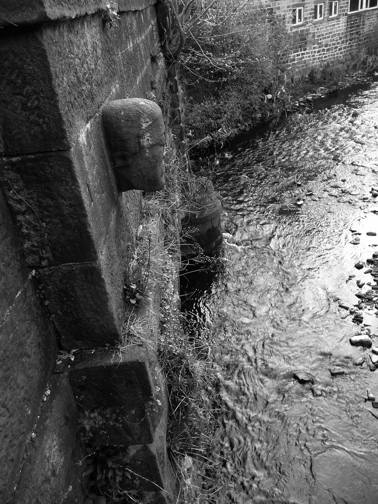
The stone head carved into Black Pit Aqueduct at Hebden Bridge
Original link.
Later, the canal would create yet another new community, the families who would operate the infrastructure of locks and toll houses and those who would crew the barges themselves or drive horses along the towpaths. The way of life of canal workers was quite different from that of river communities: especially with the advent of steam power, boats were not tied to currents, while the managed pounds were not subject to droughts or floods. When moored on the still waters, narrowboats could serve as permanent homes, and became a focus for distinctive vernacular art, music and folklore. As well as transforming the physical landscape, canals created entirely new human geographies and connections, and an unprecedented sense of people on the move.
Four days before Christmas in 1804 saw the Grand Opening of the Rochdale Canal, with a yacht procession from Rochdale to Piccadilly Wharf, Manchester that was witnessed by huge crowds. Their excitement was justified. The Rochdale Canal was the first to cross the Pennines and the only one to do so without a tunnel, thus opening new localities at the Summit. It was now possible to send a 70-tonne cargo overnight from Manchester to Todmorden in Yorkshire by ‘fly boat’, hauled by a relay of swift horses. Investors and industrialists also had reason to celebrate. Raw materials could be easily sent inland, creating a second wave of cotton towns like Todmorden and Leeds, and coal would gradually relieve the need for water power in the valleys, while transforming their vistas into the grimy Victorian archetype of soot-blackened mills and chimneys. Yet the landscape was transformed in other ways too, into a habitat for fish and waterfowl. Nature was changed, as the din of geese at the Summit still attests.
In 1839, the second year of the young Queen’s reign, the canal reached its peak of trade, generating £62,712 [£6.5 million today] revenue from 875,000 tonnes of cargo. Two years later, the Manchester and Leeds Railway opened along the same route as the canal. In various places between Hebden and Todmorden the railway runs only few yards from the canal and the later trunk road, all three modes of transport snaking through the deep valley. While the railways soon superseded the waterways in terms of speed, much of their civil engineering derived directly from the earlier designs of cuttings, embankments and bridges and drew on the expertise of the next generation of navvies. Continuities were seen in other respects too. Rather than causing a steep decline in the Rochdale Canal’s fortunes, the railway brought synergies that kept barges moving for another century. Bulky, non-perishable goods were still cheaper to move by water, freeing up space for food supplies and of course, passengers to travel by train. With the two routes cheek-by-jowl, even more spectacular structures were added – the Gothic turrets of Skew Bridge Viaduct at Gauxholme Lock or the three million bricks that form the railway embankment into Todmorden station [the ‘Great Wall of Tod’], and in Manchester itself, the multistorey connections of rail and water around Deansgate.
Lending its financial strength, in 1855 the railway leased the whole canal infrastructure, which included the Pennine reservoirs. Part of the lease terms allowed the railway to open Hollingworth Lake to the general public. Visitors could reach it by train from Manchester, with a short walk or trap-ride from Littleborough Station. Indirectly, the canal created yet another landscape out of nowhere, one of the earliest working-class tourist resorts. Around two purpose-built hotels were pleasure gardens, gaslit dance terraces, a fairground, camera obscura and an early photographic studio. The ‘Weighvers’ Seaport’ might be considered the world’s first theme park, the ‘theme’ being the lake itself as water became identified with leisure and health as well as trade. Rowing boats and two paddle-steamers were popular attractions, as were opportunities for freshwater angling and open water swimming [Captain Matthew Webb trained here before swimming the Channel]. In several hard winters, the lake froze enough to allow skating and curling matches. A less typical use, during the First World War, was as an army camp where amphibious military operations were rehearsed.
The war marked an end of Britain’s industrial heyday, and traffic on the canal began to dwindle. With locks operating less frequently, less water was needed, and the reservoirs were sold and converted to a more mundane purpose, providing a domestic water supply to Oldham and Rochdale. Water was drawn at such a volume that Hollingworth Lake had nearly dried up a decade later, revealing houses hidden since 1800. The last complete journey on the Rochdale canal was made in 1937, with no further navigation by public craft from 1952.
Abandoned and apparently unloved, the fate of this canal echoed much of Britain’s attitudes to its post-industrial landscape, an ambiguous nostalgia coupled with a desire to forget. The canal’s decaying infrastructure pointed to histories of grinding toil and colonial exploitation that continue to trouble us, and to legacies of illness and industrial disease, but also signalled mourning for lost communities and vanished prosperity. Gaunt ruins, like 17th-century Clegg Hall in Rochdale [restored 2011], developed a sinister, haunted reputation. Deserted towpaths, eerie and hazardous, had long attracted superstitions of boggarts, sinister spirits connected to stretches of the waterway, or of Jinny Greenteeth, a witch who lures children to walk onto the precarious carpets of duckweed. Later, urban myths like ‘The Pusher’ became associated with unexplained deaths along the waterway in Manchester, while walkers in recent years claim to have seen cryptic animals in the depths. The filthy rubbish-strewn water was an obvious place of danger, best ignored. Newer developments like the M62 motorway at Castleton or a supermarket at Failsworth simply cut through the canal, making future use seemingly impossible.
But along the canal, at least, nostalgia triumphed, and perhaps a deeper sense of hope and renewal. In 1965, an Act of Parliament to irrevocably close the Rochdale Canal was opposed by a grassroots preservation movement, the Inland Waterways Association, and in the 1970s popular protest staved off complete destruction. Ultimately, it was economics that determined the fate of the canal: closing it would prove more expensive than saving it and by this point, canals had once again created viable new communities, this time of tourists and narrowboat dwellers. The Rochdale Canal Society was formed in 1974 to take charge of what remained, and the following year a Job Creation Scheme began to fund work placements around Rochdale. In circumstances of increasing unemployment, several thousand local young people found work experience restoring the canal, which increasingly became a focus of local pride and, yet again, the heart of a nascent community. From 1983, thanks in part to European and Lottery funding, stretches of the Rochdale Canal reopened. Once again, new industrial architecture was created – in 1996 the canal was reconnected to the national network with the construction of a lock at Tuel Lane, Sowerby Bridge, the deepest ever built in the UK. Then in 2001, Rochdale’s busiest roundabout was raised in so that a new waterway beneath the M62 could open the following year, enabling the Transpennine canal route to fully reopen.

Fully restored to its former glory.
Original image link.
The rise of road transport spelled the end of the canal’s function as a mode of transport for the industries along it, mines and mills that have in any case disappeared. The goods that traverse today’s landscape do so primarily on lorries carrying containers loaded directly from ships. The era of the canal as a busy, noisy thoroughfare is definitively over. Its new identity as a site of calm, stillness and slowness is inescapable – the sounds of its industrial past forever absorbed into the submerged architecture that underpins it, replaced by birdsong and the soft chug, chug of the narrowboat motor.
– Rebecca Morrill + Guy Tindale, April 2021
[Acknowledgements: research into the Rochdale Canal’s history by Jennie Bailey, and its folklore by Morag Rose and John Billingsley]